Showing posts with label Route 1. Show all posts

Monday, September 19, 2016

Northbound on US Route 1

Last winter Jim accompanied me to fulfill the first part of a long-time dream: driving the length of US Route 1, which goes from Fort Kent, Maine, on the northern border with Canada, to Key West, Florida, the southernmost town in the Continental United States, 90 miles from Cuba.
See Route 1, Day Eight: Key West!

Tonight we’re in Wells, Maine. We left home at 1:20 p.m., drove down Storrow Drive to the Mass Pike, got on Route 1/I-93 and headed north. We stopped in Portsmouth, New Hampshire, for dinner: Jim got some restaurant suggestions from a friend who lives there. From the restaurant deck we could see The Strategic Harmony, a freighter from Singapore. After dinner we walked down the street for a closer look. Two huge cranes were unloading…sand from Chile. Unexpected.

Before we got to the restaurant we found a coffee shop/used book store, browsed for a while and bought about seven books. We’re incorrigible book buyers.

As dusk fell we bought gas in York, Maine and Jim worked his internet magic. First night’s stay: Coast Village Inn, a modest motel with a good deal on Expedia.

Tuesday, February 2, 2016

Grampa's Travel Notebook

It’s a sunny July day and my sister, brother-in-law, brother Timothy, and Jim drive my 91-year-old father to the broken-down ranchhouse where he grew up. It’s outside of Highwood, Montana, east of Great Falls, abandoned in a golden field of wheat. Dad stays in the car, not wanting to disturb memories of his childhood home, but we walk down the pickup truck tracks over the prickly wheat stubble. Wearing capris and with bare ankles, I walk gingerly to avoid being stabbed by the sharp wheat stocks. My brother, Timothy, strides ahead of me in his boots and jeans, shaking his head at my foolish clothing choice. He spent summers here as a farm hand when he was in high school and loves the Big Sky Country. The old house was electrified years after it was built, but never had running water. The old outhouse (a two-holer) is tipped over in the back yard.

           In the distance, behind the old barn, some people are shooting targets with their guns. Walking around the house we discover the only way in, through an open window, and slowly climb in, avoiding the nails sticking up on the sill. The place is a mess, strewn with picked over magazines, random old feed company calendars, and animal droppings. Upstairs I discover three black student composition notebooks, the kind with the marbled cardboard cover and lined paper bound together with string. They were designed in the days before cheap metal spirals, though I still can buy them at Staples.
The first notebook is titled "State Routes Traveled" and the heading of page one is ‘Alabama’. Each subsequent page has a state name, all in alphabetical order. (There actually aren't any routes listed in Alabama.) My grampa drove all around the country with Gramma. Winter was the slow season on the wheat farm, which gave them the freedom to roam the highways.
I’m thrilled to find the notebook and flip through it with anticipation. What sort of travel journal did he leave? I find each page lists highway numbers and place names, nothing more. They are ledgers of every highway he’d traveled on. No motels, no historic sights or tourist stops, nothing but rows of highway route numbers and place names. Arizona: #69---Jct #79 to Phoenix. Maryland: #39---W Va line to Jct #219 US. Out of hundreds of entries four are dated: 1964.
           The second notebook is titled "Routes North & South Traveled" and the third "East & West Routes Traveled". I take the notebooks with me, thin reminders of my grampa and his travels.

I know from family stories that Grampa drove to each of the lower 48 and took a photo of the state capitol. In my childhood I saw some of those pictures. That gene has been passed down through the generations: I visited each of those 48 states with my kids in 1995. Our son, Matt, is halfway through running a marathon in all 50. He’ll run the Boston Marathon for Patriots’ Day on Monday, April 18th, in honor of David, as part of the Leukemia & Lymphoma Society. (If you want to know more, or donate to the cause, here’s the link: http://pages.teamintraining.org/ma/boston16/mjohnston.)

My oldest brother, Steve, tells me that Grampa Hazen drove much of Route 1. Here's a notebook entry:
#1 US                                                                                          Baltimore Md. to
              Columbia S.C.
               Daytona Beach Fla to Key West Fla


          He was a wheat farmer who worked hard from spring to harvest and then traveled in the winter when the work was done. He took a photo of every state capitol of the lower 48 and in retirement traveled to Alaska and Hawai’i to finish the job. There’s an “all of” project.

Tuesday, January 26, 2016

Would I Do It Again?

We returned to Lexington from our two week road trip exactly two weeks ago. In Route 1, Day Eight: KEY WEST! Maggie T. comments that she wants to convince Jeremy to drive down to the Florida Keys via Route 1. Do I recommend it? Would I do it again?

Sometime after my epic Cross Country Trip in 1995 (15,900 miles, 48 states, 3 Canadian provinces, and 1 Mexican state, with six kids ages 4 to 14, in a blue minivan with a purple tailgate pulling a pop-up tent trailer), I dreamed of traveling Route 1 from Maine to Florida. I love the idea of doing all of something: driving through all 48 states… hmmm, actually, I can’t think of any other ‘all of’ things I’ve done.

Further back in time I read William Least Heat-Moon's travel book Blue Highways. It was one of the inspirations, along with John Steinbeck’s Travels with Charley, for my Cross Country Trip. The ‘blue highways’ are the secondary roads, color-coded blue in Rand McNally’s road atlas. He didn’t want to zip along interstates; he wanted to experience real America.

       Route 1 is not a ‘blue highway’, but I imagined I'd find a piece of America, more real than the interstate. What did I mean by real? I wanted to find diners with fresh pies on display                          


kitschy tourist traps, cheap motels.
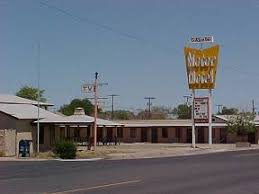
                             

 I wanted to experience the highway that has connected Maine to Florida since 1926. I did find diners, and plenty of cheap motels (I chickened out there, fearing bedbugs and drug busts), but in the suburbs, instead of local color we passed mile after mile of Home Depot, Bed Bath and Beyond, Kohl's, Wal-Mart, and Target.
                    

 In areas too unpopulated to support those big box stores there were still the ubiquitous CVS and Walgreens, often just across the street from each other. Route 1 is teeming with car dealerships: Honda, Chevrolet, Hyundai, even Porsche, and BMW.
                                         

Small towns often had used-car lots. I can just imagine an early twentieth-century family getting in the family buggy, going to Route 1, and trading their horse for a Ford. Whatcha think?
                         

What surprised me? The lovely villages of Rhode Island and Connecticut, with their brick two-story shops
                      

and rolling countryside. Boston Road in Yankee Bronx. (It's part of the original 1673 'King's Best Highway' or Boston Post Road that was established between Lower Manhattan and Boston.) In Philly, our highway dipping below grade, then becoming a grand boulevard, passing handsome stone and brick houses. I didn't expect the loneliness of South Carolina and Georgia along Route: we passed mile after mile of tall thin pine trees in sandy soil.

The Historic Route One website suggests, “Avoid the congestion of East Coast interstates such as Interstate 95.” The reality is that on Route 1 we averaged twelve miles an hour for three hours through Miami. Since Route 1 doesn’t bypass cities and towns like the interstates do, it has several hundred traffic lights from Massachusetts to Key West. Through the densely populated areas, there is plenty of congestion. I can imagine taking a trip to explore smaller roads or even a section of Route 1; I feel no need to traverse the length again.

So, I've driven to all 48 states and all of Route 1 south of Boston. Jim and I plan to drive the northern section of Route 1 this summer. We’ll start at the Tobin Bridge and pass the northeastern cities and towns of Massachusetts, cross a bit of coastal New Hampshire, and then follow the coast of Maine till Route 1 turns inland toward Caribou and then Canada. "I'm goin' out on a limb here" (Groundhog Day): I don’t expect to see a big box store once we pass Freeport, Maine (home of many outlets); I do expect to see a lot of pine trees of the northern variety.

       Then I can brag about doing 'all of' two things: 48 states and Route 1.

Thursday, January 14, 2016

The Trip North

On January 7th, we leave Route 1 North in Miami and take Florida’s Turnpike through the Everglades. In the 84 miles between Fort Pierce and Three Lakes there is just one exit, at Yeehaw Junction; it’s lonely highway. We are surprised at how much of Florida is wilderness. At sea level and treeless, but wild nonetheless.
We sleep in Lake City in north-central Florida and on January 8th we breakfast with Jim’s cousin, Kristin. Frank is at work, so we can’t thank him personally for the wonderful day we had in Key West with the free tickets he arranged.
In the afternoon we visit my brother, Timothy, in Savannah and he gives us a tour of The Home Depot, where he works. Supper is in Charleston, South Carolina, with Jim’s sister Mary and family; we sleep in their FROG. That’s a Charleston architectural feature: Finished Room Over Garage. Theirs is an oasis of peace and serenity.
January 9th is our big travel day: 550 miles. After a breakfast of steel-cut oats with John, we leave Charleston, drive through North Carolina and southern Virginia, and have supper with my Bryn Mawr College friend, Stacie, and her husband Frank, near Richmond, Virginia. Then I drive through heavy rain on I-95 and I-495 to Bethesda, Maryland, where my brother Steve and his wife Maria host us for two nights. On the way we pull off I-95 in Aquia, Stafford County, Virginia, for gas and find ourselves briefly back on Route 1. En route we take turns driving and reading The Good Husband of Zebra Drive, by Alexander McCall Smith.
January 10th is our second Sabbath on the road. We attend the Rockville Maryland Ward, adjacent to the Washington, D.C. Temple, then drive around the temple grounds. We made a lot of trips to the temple in the years before the Boston Temple opened in 2000, but one day stands out: June 5, 1979.
Supper is a happy, noisy affair with my niece, Maria, her husband, Karl, and their four energetic young children. They remind us of us twenty-two years ago, when we had kids ages one to eleven. What sweet (sometimes) memories.
January 11th we stop at Peter’s and Xiomara’s for supper; R’el and Mike visit too. At 10:30 p.m. we start on our final 200 miles. At 2:30 a.m. we sink into our own bed. Two weeks on the road.

Monday, January 11, 2016

Route 1, Day Ten: The Last Sunset

It's January 7th, and Roberta cooks up some bacon and scrambles eggs for our breakfast. Then it’s time to say good-bye to her and James.

Frank, husband of Jim’s cousin Kristin, grew up on Key West. His family lived there for multiple generations, coming originally from the Bahamas. He arranges free tickets for us and we spend the day as unabashed tourists. The Shipwreck Museum reminds me of the Nantucket Whaling Museum, complete with a lookout on top.


The ocean around Key West was the site of an average of one shipwreck a week for many years. “Wreckers” in small boats would go out in the storms and hurricanes to rescue passengers and crew, which was the first priority, and salvage any cargo they could bring in. Depending on the effort required and the risks involved, wreckers received a percentage on the sale of the salvaged goods.
The Conch 'train' threads its way through the streets of the old town, hitting the major points of interest, including the colorful buoy at the southernmost point in “the continental U.S.” It seems a stretch to call an island 100 miles from the mainland “continental”, but whatever floats your boat.
The Key West cemetery is full of above-ground crypts; many of them are stacked. It looks like an eerily deserted white marble city for children.
Image result for key west cemetery images


I enjoy seeing the Caribbean fish in the aquarium, including my personal favorite: the fairy basslet. (Have I mentioned I like purple?)
                                               
By 3 p.m. we’re touristed out. I give up trying to read all the biographical sketches in the historical sculpture garden: it has about 20 or 30 bronze busts. We eat at a restaurant specializing in Cuban cuisine. The pork chops marinated with lime and garlic are extremely tasty. Since we first entered the town two days ago we’ve heard roosters crowing frequently. When cock-fighting was banned in the 1970s, the birds were released and their descendants roam the island freely. It is illegal to capture them or harvest their eggs.

About 4:30 p.m. we leave Key West and drive Route 1 North, a.k.a. the Overseas Highway, in daylight. Around 5:30 p.m. I spy a huge orange disk behind me, a quick glimpse of the setting sun. Too bad we can’t be at the sunset festival tonight.

Sunday, January 10, 2016

Route 1, Day Nine: More Research Required

January 6th we wake to a rainy morning on the sailboat docked at Stock Island in the Florida Keys. Roberta scrambles eggs and cooks up sausage for our breakfast. We’ve been on the road for eight days, so it’s laundry day. James fires up the dinghy and gives us a ride to the laundry/shower house. I put our laundry in the washer and head for the shower. It doesn’t have a ceiling, just a palm thatch roof about 15 feet above my head. Wish I had a shower like that (during the New England summer, that is).


Walking around the marina, Roberta points out a boat completely wrapped in a red and yellow tarp with a sign:


 She says it’s termite extermination and shudders at the thought. The marina has a clubhouse with gym and restaurant and a small sandy beach. Unexpectedly, all the sand on Key West is imported from the mainland.
After the laundry is done James takes us in his dinghy to Old Town Key West. Earlier in the day there had been a small craft weather advisory, but he thinks it will be alright. (Obviously we make it.) We motor along in fairly open, choppy water. It does occur to me that I have put my physical safety in his hands: I can swim a mile in a swimming pool, but am not confident of my survival in open water. He doesn’t offered life jackets, and I’m too cool to ask, but before we are underway, when he opens Jim’s seat to tinker with the battery, I notice the bright orange jackets and rehearse mentally how I will retrieve them if we capsize. Closer to shore, James winds through the “mooring field”, an area of the harbor with dozens of buoys for rent, each tethered to the sea floor. Boat owners tie up their boats and go ashore by dingy. The marina where we are sleeping has actual slips and docks: our car is a few yards from the sailboat.
On land once more, we have a meal at Sloppy Joe’s. The eponymous owner, Joe Russell, was great friends with Ernest Hemingway. Hemingway is big on Key West. He only lived there for 8 years, but he wrote some of his greatest works, including A Farewell to Arms, there and his home is a Mecca for aficionados. For dessert at Joe’s we have key lime pie, again.
Then we head for the west end of the island. Crowds gather there every evening to watch the sun set. There is a man with large glasses, an unassuming Clark Kent kind of guy, without the handsome actor behind the glasses. Like a businessman from the fifties he wears a white shirt, with combed-back hair, but also sports diamond ear studs and is reading a man’s palm. A steel band pierces the air with bright West Indian music. Street performers have laid ropes on the ground, defining makeshift stages. The cruise ship Constellation sounds its bass horn and we stand above the dock watching the workers lift heavy ropes thick as your arm off the bollards to release the ship. Counter-intuitively (to us), the ship pulls away from the dock, sideways, staying parallel to the shore, and then turns 180 degrees to exit the harbor.

                                                     
We walk through the crowds, passing a street performer with an annoying voice and about six cat carriers. The performers all have the technique of warming up the crowd by acting like they’re about to start, but it’s mostly talk until a good crowd has gathered; I don’t have the patience to wait for the cats to appear. Another performer is waving a flaming torch around. He has a compelling technique: all through his show he’s encouraging people to step right up to the line. He even calls out to passers-by: come on, you in the pink, step up here.
After watching his show we find Kermit’s and buy a whole key lime pie to share with James and Roberta. After four pies my study proves inconclusive: more research will be required.
                           

Wednesday, January 6, 2016

Route 1, Day Eight: KEY WEST!

January 5th: we leave Banana Bay in Marathon around noon and head west on Route 1, aka the Overseas Highway. Just like rural South Carolina, with its rhythm of signs, DO NOT PASS, PASS WITH CARE, this highway develops its own rhythm of names: Big Pine Channel, Big Pine Key; Torch Channel, Torch Key.

Jim stops the car just beyond the green Key West sign


then I take the wheel for the final miles. The traffic into Key West crawls, but I’m content. I pass the end of Route 1 sign and search for parking. Just as our optimism flags, an on-the-street spot appears, with an eleven hour limit. We walk back to the highway signs: there is a constant stream of tourists taking pictures of the “End 1, Mile 0”, and “Begin 1 North, Mile 0” signs. I brag to the tourists who offer to swap phones to get group pictures: We started in Boston and drove Route 1 all the way here! It took a week. They seem suitably impressed, but of course they have no idea.


R’el emails me a photo of her and me at the same spot on the 4th of July, 2008, when she was doing a hospital rotation in Miami. We went scuba diving in Key Largo and then drove to Key West. We ate key lime pie and bought Stewart's Key Lime soda.


I buy postcards and a ‘Route 1, Mile 0’ T-shirt and we find a ‘hop on, hop off’ Cityview tour trolley. We ride the circuit twice. I find it disorienting to have water on three sides of such a small area.

We stroll down Duval Street and find a cute little bistro with an Argentinian waitress. I have shrimp and penne, Jim has chicken and scalloped potatoes. We again finish off with bread pudding with ice cream and key lime pie. The pie is different from the St. Augustine version. It’s not as creamy and tastes more like fresh key limes with a touch of rind. I like them both.
Jim signs up with Airbnb and finds a sailboat to sleep on. Our hosts, James and Roberta, are from Goshen, Indiana. Their boat is berthed at a marina on Stock Island, just east of Key West. We’re below deck, in a room slightly bigger than the double bed, which is tapered at the foot. We have a private powder room. It has a shower, but they use it for storage. The marina has showers and a washer and dryer; that’s where we’ll be tomorrow morning.

As I write this I feel a gentle sway. Ah, to be rocked to sleep in the Florida Keys.

Tuesday, January 5, 2016

Route 1, Day Seven: Twelve Miles an hour through Miami

January 4th and we head down the Florida coast. We stop north of Fort Lauderdale and visit two apartments that Jim’s brother Jeff owns: Coral Springs, where many of the streets are a variation on ‘coral’: Coral Ridge Drive, Coral Springs Drive, Coral Hills Drive; and the town of Margate. These towns abut the Everglades, which are so flat that a short man-made embankment hides them from our view.

We press on through south Florida. Route 1 goes right through the heart of Miami. Jim’s a good sport: we average twelve miles an hour for three hours. Once through Miami we stop at Pollo Tropical, a Caribbean-themed fast food place. I have barbequed ribs, balsalmic tomatoes (maybe not so West Indian), and boiled yucca (very West Indian), a mild-flavored starchy vegetable; Jim has pulled pork.
Just outside of Florida City civilization as we know it ends. Night has fallen and we see no lights off the highway. The “Overseas Highway” is Route 1 and the only game in town to reach the Keys (unless you own a boat or fly into Key West). We stop at the Banana Bay Resort for the night.
Ironically, a heat wave broke just before we arrived in Florida. High temperature: 55 degrees. So the outdoor pool holds no allure. The Floridians are grateful for the cool; I was hoping for some heat.

Route 1, Day Six: Sabbath in Melbourne, Florida

First Sabbath day of the new year: January 3rd. We had emailed Darin and Sarah Ragozzine earlier and now meet them at church. They lived in Arlington (Massachusetts) from 2009 to 2011 and once a month were ‘inviters’ for our ‘weekly gathering’ suppers. Chloe is now 9 ½, Abby, who was one of our nursery children, is five. Nathan was born after they left. Sarah fixes a delicious homemade meal of taco salad with chocolate cookies and gingermen for dessert. We play Go Fish and Trouble, their new Christmas game.
Preparing to sleep for the second night in the same bed feels great. We’ll get an early start tomorrow and head for the Keys!

Route 1, Day Five: Waycross, Georgia to Melbourne, Florida

On the second day of the new year we finish our drive through Georgia and head for the Florida coast. As we enter St. Augustine we stop at Fort Menendez, intrigued by ship masts towering over the wooden fence. Jim pulls over and we enter a gift shop: the first of our trip.
We tour the fort with a couple from Miami and their three children. Using a feather quill pen and a bottle of black ink our guide, Victoria, signs our entrance papers. She makes it look so easy, but our own sloppy signatures highlight her skill. She hands each of us a small scroll with questions and a twentieth-century stubby pencil to jot down answers as we go along.
In the fort we learn to dip candles. Four long strings hang straight down from thin pegs attached to a flat wooden disk with a handle. Grasping the handle, I dip the strings in a vat of melted wax, careful not to dunk the disk, then lift the wax-covered strings out and count, “Uno, dos, tres” and dip again. The pause lets the thin coating of wax cool and harden before dipping again. We each take a souvenir candle.
We learn to weave thin strips of wood into a wattle for fencing and dip a bucket on the end of a rope into the open well for water. (Don’t worry, middle-school science teachers, the well is covered with a locked iron grate.)
A young man from a Paiute tribe in Arizona gives us a humorous and informative tour of the Native American village. The Timucua people that Ponce de Leon met in Florida were gentle giants: over six feet tall, with good teeth; Ponce was about four feet seven and sixteenth-century Europeans had notoriously bad teeth. To enlist as a soldier one needed two top and two bottom teeth in order to rip open the paper cartridge of gunpowder and load a musket.
The final stop on the tour was the life-sized replica of a Spanish galleon deck. It’s tiny. Victoria, who has returned for this segment, shows us how to play ‘Close the box’, a simple counting game with dice. In the gift shop I have 20% off for answering all the questions on my scroll, so I buy a miniature version with tiny dice.

We head into old St. Augustine, driving through a small neighborhood with sandy alleys. The pedestrian mall near the old fort is packed with people and the standard tourist places: clothing and art shops, ice cream stands, restaurants, as well as the oldest school building in America. We pick a restaurant and have delicious fried green tomatoes, fried oysters, a blackened fish sandwich, key lime pie, and pound cake with ice cream.
While Jim takes a picture for some Colombian tourists near the old city gates I hear the sound of spoons playing. I put a dollar in the young man’s hat and chat. He’s from Kingston, New Hampshire. (He was pleased to hear we lived in Manchester.) However for the past six years he’s been working in Oregon. He and some buddies just bought a boat in St. Augustine. They’ll stay south for the winter and then head up to New England. “So this is your food money?” I ask, glancing at the few bills in the hat. “Yeah, I guess.”

Back on the road we head for Melbourne. It’s Saturday evening and we’ll stay at Candlewood Suites for two nights, and meet the Ragozzine family at the Melbourne Ward tomorrow. We enjoy the luxury of two nights in one hotel and establish our portable library on the window sill.


Monday, January 4, 2016

Route 1, Day Four: North Carolina, South Carolina, Georgia

                                         Happy New Year's Day!
We leave Apex at 8 a.m. and travel on limited access Route 1 for an hour and a half. Rockingham, North Carolina, is a handsome town, lots of porches and houses of various sizes, including a lovely two-story Colonial brick house, and a Victorian with a wrap-around porch. The streetlamps are shaped like my Bryn Mawr lantern (sans owl)


We drive right through the town center: a two lane street with parking along the side.
After Rockingham we enter South Carolina. Immediately there is a sign for fireworks and the two lane road falls into a rhythm of signs: ‘Do not pass’ and ‘Pass with care’. Route 1 has become very rural. We pass the Sand Hills State Forest to our east and the Sand Hills National Wildlife Refuge to our west.
The small town of McBee (population 900) has streetlamp holiday decorations: snowflakes. That makes me laugh. Perhaps it snows here, but more likely not.
Northeast of Columbia, the state capital, we stop to eat at Hot Box. The motto is “Eat now. Die later.” Jeremy, the co-owner, is an earnest, energetic young man with a paisley black bandana across his forehead. He talks us through the menu of about 18 items. I have the twin deep-fried hot dogs with fried dill pickle spears. Jim goes for the deep-fried chicken breast and deep-fried mushrooms. (Do you detect a theme here?)


Hot Box has been in business for exactly two years today. However, they are shuttering the doors in two days. Jeremy explains that the October flood meant there was not enough clean water to run their kitchen. The rain also caused roof damage, which the landlord isn’t willing to repair. Falling ceiling tiles discourage customers. The holiday season has been slow for business too. Jeremy describes his restaurant with great passion. It’s sad to see it fail. Jim buys me a souvenir Hot Box bracelet, Army green with red accents.
As we drive through downtown Columbia, I spy a dome, cry out, ‘zip!’ and say, “Let’s stop, for Matt.” Our son Matt has a goal to touch all 50 state capitols. My Grampa Hazen took pictures of all 50. It’s in the blood.

It’s New Year’s Day, so everything is very quiet. The State Capitol grounds are lovely, complete with a flowering bush.

We cross over the Savannah River into Augusta and the rest of the afternoon and evening is spent driving through rural Georgia. No big box stores here; no national brand car dealerships either. But Route 1 is still an auto road: occasionally there is a small dealership, selling mostly used cars.
We end our day in Waycross, Georgia, just north of the Okefenokee Swamp. What a lovely name for a true crossroads: on the map Waycross looks like a six-pointed star.

Sunday, January 3, 2016

Route 1, Day Three: Virginia to North Carolina

On New Year’s Eve, we spend the day driving from Dumfries, Virginia, about 30 miles south of Washington, D.C., to Apex, North Carolina, about 15 miles south of Raleigh. We pull out of the Candlewood Suites at 12:17 p.m.


We pass a handsome two-story brick building named Williams Ordinary.


An ordinary was an establishment that served food and offered lodging in the days of horse and stage coach travel.

We drive through countryside and built-up city areas in Fredericksburg, Petersburg, and Richmond. When we need gas Jim stops at a gas station, but it turns out it is for ‘fleets only’; there’s no obvious way to measure the fuel. Jim says he was hoping for some local color, but not that local. We push on and find a standard gas station before we run the tank dry.

In Ashland, Virginia, north of Richmond, we stop for lunch. It’s New Year’s Eve and first two places we try are closed. However there’s a hoagie place, San-danos, that’s open. The owner is behind the counter with a snug little kitchen with a grill for meat and counters for making hoagies. I didn’t know hoagies were a thing in Virginia, but he is from Delaware, so that probably explains it. I order an Italian hoagie and Jim gets a Philly cheesesteak, made fresh as we watched.
There’s a narrow wooden counter under the front window with four bar stools. We sit and munch on our sandwiches and chat with the owner. (Sorry, but I didn’t ask his name.) He had been a banker in Delaware and started the hoagie shop twelve years ago. His grandparents were Italian. As we speak he cleans up the kitchen, puts extra food in the freezer, and preparing to close for the holiday as soon as we leave.

Between Fredericksburg and especially after Richmond, the scenery changes: mostly rural, one or two lanes in each direction, no shoulders, buildings close to the road, and few stop lights. No big box stores. There are auto sales, but they are local places, without the huge lots of the national brands (Ford, Honda, Chevrolet, etc.).

We approach Raleigh, North Carolina with dusk falling. Route 1 enters the beltway, I-440, bypassing the downtown. I must admit I’m relieved not to go through another city center. It’s dark, I’m tired; it’s been a long day of travel with the speed limits changing from 55 to 45 to 35 and back to 45 to 55.

We stop for the night south of Raleigh, in Apex. We tell the motel desk clerk what we are doing and he smiles. He has driven US Route 41 from Wisconsin to its end in the Upper Peninsula of Michigan. He says the highway just ends and you turn around and go back. Well, that’s what Route 1 does too.

Friday, January 1, 2016

Route 1, Day Two: Princeton, New Jersey to Dumfries, Virginia

On Wednesday, December 30th, I wake up at 10 a.m. in the Princeton Inn. We take a relaxed approach to the morning, requesting a late checkout. When I call down, the front desk clerk says, without skipping a beat, “The latest checkout time is 12:30 p.m.” Perfect.
We pack up, then leave our luggage on a cart near the front desk. (Jim is sold on hotel luggage carts.) I feel like a rich lady traveler with all this luggage. The cart even has brass (colored?) curved poles, just like the Waldorf, without the red velvet. However, our stack includes a red and white Playmate cooler from the early 80s, which lowers the class a bit. I just can’t travel without packing food.
Jim narrates our walking tour of Princeton, past his dormitories, Brown and Little, and Blair Arch, where the 10th reunion photo was taken, into the old bookstore which is now just T-shirts and convenience store.


On A floor in Firestone Library the study carrel where Jim spent hours working on his senior thesis is gone. Of course there are all sorts of interesting books; Jim often would pick up something new to read rather than study.
After the walking tour we drive around and find our first apartment at 155 Ewing St., which we sublet in the summer of ’79. Two workmen are there, and let us step in to see the second floor studio apartment. The wrought iron banister at the top of the stairs has been replaced with a half-wall; the kitchen and bathroom are updated. One workman is painting a door.
We drive out to the LDS chapel on Alexander, then take Route 1 north two intersections to Harrison St. to return to Route 1 south exactly where we had exited the day before, at the gas station where I waited in a long line for gas back in the shortage days of the 70s.
Crossing the Delaware River we see the bridge with big red letters: “What Trenton Makes the World Takes”. The drive through Philly and suburbs changes character every few minutes: below-grade street, commercial areas, townhouses, grassy tree-lined boulevards, and twelve-lane highway. Dusk has fallen by the time we reached Longwood Gardens near Brandywine, making the tall deciduous trees wrapped in red Christmas lights stunning. There was even one with multi-colored lights.
We drive through the Maryland countryside in the dark and in Perry Hall, Maryland, Jim pulls into the Double T Diner, a large and gleaming establishment with apple turnovers on display at the front entrance and a revolving dessert case.


Jim knows how I love the romance of diners. Unfortunately my dinner is too much food to even think about sampling any desserts. I enjoy Maryland crab soup, stewed lima beans, real mashed potatoes, and a huge and delicious broiled crabcake. I order two, but can’t eat the second until supper the next day.
We drive through quiet city streets in Baltimore, past the quintessential white stone steps of the row houses. Bold pedestrians in dark winter clothing cross the street in a nerve-wracking way, but no mishaps occur. Pressing on to the District of Columbia we drive down the mall, past museums of art and natural history, and the large federal buildings with huge Greek columns, turning left in front of the Washington Monument, and passing the Jefferson Monument and Tidal Basin. 30 miles south of the District we stop on Old Stagecoach Road in Dumfries, Virginia, at a Hampton Inn. Another late night of travelling, but at least we avoided heavy traffic in Baltimore and Washington.

Thursday, December 31, 2015

Route 1, Day One

At 7:29 a.m. on Tuesday, Dec 29, we leave Annie and Shawn at the curb of Terminal A at Logan Airport. US Route 1 crosses the Tobin Bridge just north of Boston proper and near the airport it is combined with I-93, which has come from northern New Hampshire. South of Boston I-93 ends, and shortly afterwards Route 1 peels off I-95. We pass the “Auto Mile” in Norwood, where car dealerships line the road, and see our first pre-Holiday Inn, mid-century motel: a long, low-slung building with parking in front of each of about ten to fifteen units’ doors. I expect to see many more as we travel.
With Jim napping (short night for us), I drive across a bridge into Pawtucket, Rhode Island, and face its Public Library, an imposing monument to learning.


I take a right at a fork in the road and drive many miles before I realize I've lost Route 1. Hoping to recover without disturbing Jim’s sleep, I carry on. I finally find I-295, which junctions with Route 1 but again guess the wrong direction. When I realize my mistake I have to backtrack all the way to Attleboro, Massachusetts. Jim wakes up and is surprised we aren’t farther along, so I admit I’ve driven in a huge circle for the past hour. When we arrive again at the fatal fork in the road for the second time, I go left and promptly lose Route 1 again. Jim navigates with the GPS, we wander around, and eventually find Route 1. I’m still not sure how I lost it, but trust me, Route 1 South in northeastern Rhode Island is hard to follow.
  The drive south of Providence is lovely. We drive through the charming town center of Westerly, founded in 1669. It reminds me of West Hartford, Connecticut: one and two story shops line the road. We drive near the Atlantic Ocean, though we never see it, just highway signs for various beaches.
Connecticut surprises me: two lane roads through woods and villages. There are areas of car dealerships and big box stores, but also small town centers. For mile after mile there are echoes of the old Boston Post Road: street signs, business names, even an apartment complex named “Boston Commons”.

We had foolishly thought we’d arrive at Peter’s and Xiomara’s around noon, taking 4 ½ or 5 hours to cover what is 3 ½ miles via interstate. Silly us! We arrived around 7 p.m: eleven and a half hours on the road, stopping only once for gas and once for take-out food to share from La Cuisine in Branford.
Before we get to the Riverdale neighborhood of the Bronx, where Peter and Xiomara live, we drive on Boston Avenue; what’s that doing in the Bronx? It’s all part of the Boston Post Road, established back when the Bronx was forest. It looks very much like many other commercial districts in New York City: block after block of city street storefronts.

When we arrive at Peter’s and Xiomara’s around 7 p.m. I make an executive decision. Instead of backtracking east through many busy Bronx city streets to return to the exact block where we left Route 1, in order to drive on every yard of the highway, we head directly south on the Henry Hudson Parkway, rejoining Route 1 as it (and I-95) cross the George Washington Bridge into New Jersey. It’s 9:40 p.m. and we still have two hours of driving to reach the Princeton Inn, where I had made reservations several hours earlier. Let’s just consider it ‘alternate’ Route 1.

The trip down Route 1 and 9 is very familiar. It parallels the New Jersey Turnpike, so I’ve seen this territory many times over the years, both as a youthful resident and on countless drives from New England to New Jersey and south. The most distinctive feature is the vistas: I see downtown Newark off in the distance, and can see miles of city lights. We arrive in Princeton around midnight, happy to fall into bed after a very long day.

Monday, December 21, 2015

"Light out for the Territory"

A few years ago Jim read a travel memoir, Ghost Rider: Travels on the Healing Road, by Neil Peart, drummer of the Canadian rock band Rush. After losing his daughter and then his wife to death, Neil takes off on a motorcycle through North America.

So when Jim suggested driving all of US Route 1 as soon as possible, I was ecstatic. Jim mused, “So if I want you to react with immediate enthusiasm all I need to do is suggest something you’ve wanted to do for years?” Duh!

After my epic Cross Country trip (15,900 miles pulling a pop-up tent trailer with six kids, ages 4 to 14, through 48 states, Mexico, and 3 Canadian provinces), I dreamt of another road trip: drive all of US Route 1. I grew up near Route 1 in New Jersey. Actually, we lived near 1 and 9: they share a roadbed in northeast Jersey.
Route 1 has a weird kind of romance: cheap motels and commercial strips. But it’s got Americana potential that interstates lack.
                                                                 70px-US_1.svg.png (70×70)

Why do I want to do it? I love the idea of doing all of something. I’ve daydreamed about hiking the Appalachian Trail, but reading Bill Bryson’s A Walk in the Woods opened my eyes to the massive undertaking it is. The Trail is specifically laid out to go over as many peaks as possible, and my ability to handle elevation changes, never extraordinary, is now sub-par. Also, I once got very lost and disoriented in the Lower Vine Brook conservation land right here in Lexington. How hard can it be to keep track of yourself in 110 acres of town woods, surrounded by paved streets?


But driving, driving I can do. On the Cross Country trip I learned something about myself: I don’t mind long drives. If I had a cubicle job, I might spend 8 hours sitting in front of a computer. Sitting in a driver’s seat, the windshield is very much like a computer screen. Driving rains and darkness are a challenge, but the dry daylight hours are easy.
Jim wants an unplanned trip: just get in the car and go. If it weren’t for Advent and Christmas, we’d be on the road already.
So, on December 29th we’ll drop Annie and Shawn off at Logan airport pick up Route 1 South and “light out for the Territory” like Huck Finn.